Sofia Gavrilova is a Researcher at the Leibniz Institute for Regional Geography in Leipzig, Germany. As a human and political geographer of the former Soviet space, Dr. Gavrilova works on questions of decolonization and de-Sovietization in knowledge production, policymaking, and identity construction in the South Caucasus and Central Asia.
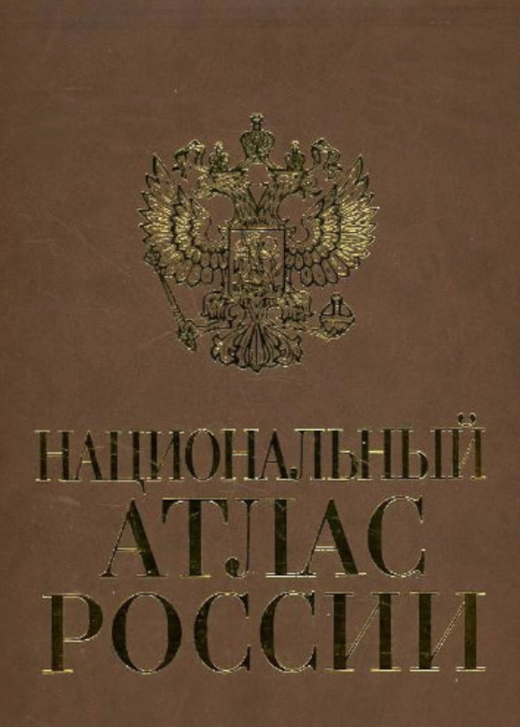
The ongoing full-scale Russian invasion of Ukraine is a conflict not only over physical spaces, but also over histories, narratives, concepts, and worldviews. The Russian justification for the violence it has visited on Ukraine is built on twisted historical narratives and politicized memories It also draws on a specific vision of space, traditions of geographical knowledge production, and the interlinked areas of patriotism and geography curricula, which have co-evolved since the 1930s. To unpack this vision of space and the claims it fosters, without jumping straight to the generalization that the “new Russian geography” is imperial or neo-imperial, we must examine how the Russian state has manifested its geographical ideology in recent years. An early example is The National Atlas of Russia, published between 2004 and 2008, a telling representation of the state's perception of its own geography during Putin’s second presidential term, although the contents of the atlas have been in development since the late-Soviet era.
The process of territorialization, the development of independent geographical knowledge, and spatial identity are inseparable parts of constructing a modern nation-state. The advent of the national atlas as a genre is closely connected to the process of nation-building from the beginning of the rise of national states as the dominant form of territorialized sovereignty in 1917-1920.. As Karen Culcasi has noted, paraphrasing the renowned critical cartographer Mark Monmonier, national atlases are symbols of nationhood, national unity, and national pride. This state-approved knowledge of national space and manifestation of spatial identity, developed through national atlases, is a means of communicating governmentality akin to a constitution, flag, or anthem.
Surprisingly, despite a robust cartographic school and Stalin's obsession with maps, the Soviet state never produced a product presented as a national atlas. On the contrary, one of the most showcased atlases, referred to as a “masterpiece,” is The Great Soviet Atlas of the World or the national atlases of other socialist republics like Cuba or Hungary, which Soviet cartographers assisted in producing. The famous three-volume Great Soviet Atlas, developed between 1930 and 1940 by a special research institute, issued two volumes in 1937 and 1940, respectively. Although the professional community considered these equivalent to other national atlases due to their comprehensive and detailed content, they present the Soviet perception of the outside world, "the Other," rather than its own spatial identity.
The first inklings of a specifically Soviet national atlas emerged in the 1960s, but concrete steps were only taken in the late 1980s, but at this point remained only at the level of plans and intentions. After the dissolution of the Soviet Union, former Soviet republics like Georgia, Lithuania, and Bulgaria, hurried to produce their own national atlases, sometimes with the assistance of Western cartographers and geographers. This effort formed part of a construction of new, post-Soviet national identities The recently formed Russian Federation was no exception to this practice. Moreover, the country’s need to rediscover a properly national spatial identity and present it to the world following the loss of former Soviet republics, brought several late-Soviet concepts back to life.
The National Atlas of Russia, which was developed at Moscow State University based largely on late-Soviet drafts and issued between 2004 and 2008, comprises four extensive volumes: "A General Introduction to Territory;" "Russia’s Natural Environment;" "Population and Economy;" and "History and Culture." Available both on- and offline, the National Atlas contains over 1600 maps, explanatory texts, and photo schemes. Analyzing the entire atlas would require a book on Russian national and spatial identity of the late 1990s and early 2000s, which I hope will be written. Here, I aim to highlight some of the most salient maps and texts pertaining to nation-building during these years.
The centralization of territory is evident in the content of the Atlas, which heavily emphasizes European Russia. Through the range of specific choices in the production of maps, but also through visualization techniques and texts, the the National Atlas focuses largely on so-called “ Central Russia.” Aside from the straightforward choice of scale ranges, which favor a more detailed representation of the European part, the texts and selection of content on certain maps underscore the historical, economic, and political importance of the center. For instance, the maps in the section titled "The formation, research, and mapping of the territory of Russia" present a conventional history of the Russian state’s development, depicting the expansion of Slavic peoples to the south, north, and east. This exposition is followed by maps of Russia's ethnic composition, specifically a map displaying "predominant" ethnicities and "others." This section includes so-called "small-numbered peoples of the North" alongside close-up and large-scale maps of Russia's European North, the Volga region, and the Caucasus.
The historicization of space, including the reproduction of state historical narratives, is evident in the section dedicated to the history of Russia. This section’s content largely consists of maps of wars and military campaigns. The historical spaces of what is again, denoted "Central Russia" depict how the Russian State was formed through successive military campaigns.
In the section dedicated to the twentieth century, for example, Stalinist repressions are entirely omitted from the Atlas’s historical map section. However, the Atlas does feature "industrial development" and a map entitled "collectivization" in the economic section. Ethnic deportations are acknowledged, but only as a part of broader migrations of the 1930s-1940s. Because these deportations appear on the same map as other "migrations"—including evacuations during the Second World War— readers are left with the impression that these population flows are, ultimately, relatively comparable. Meanwhile, the network of Gulag camps is completely omitted from both the historical and economic sections of the Atlas.
The presentation of Russia’s natural environment in the second volume of the Atlas straightforwardly reproduces the Soviet-era Marxist understanding of human-nature relations. It centers around the landscape approach to physical geography, emphasizing "nature-territorial complexes" established by Soviet scientists V. V. Dokuchaev and L. S. Berg, while excluding human-made or anthropogenic landscapes. The volume includes maps portraying nature as merely a bank of exploitable resources, with minerals and energy covered in maps dedicated to geology, and maps of forests emphasizing their "productivity" and various utilizations. The "Fauna" chapter follows suit, featuring maps of "Rabbit resources," "Fox and wolf resources," "Bear resources," and "Bird resources."
From our vantage point in 2024, the National Atlas of Russia looks like more of a monument to the transition from a late-Soviet spatial identity to a Russian one, shown in the first two decades of its existence. It presents specific, state-sponsored spatial ideas and concepts relating to a geography that, for its part, has continued evolving since the Atlas first came out. Some of the older maps now look quite outdated. The focus on the Russian Arctic, for example, which was nearly equal to the European and Asian parts in The National Atlas of Russia due to increased geopolitical interests in those regions at the time, has diminished, shifting toward the "historically" Russian lands in the "near-abroad" former Soviet republics. At the same time, the militarization of real-world space and its recent (re-)historization have sharply increased and, since 2014, have been used to justify military incursions into Ukraine.
The National Atlas of Russia thus encapsulates spatial ideas belonging to a specific period, while balancing between re-implementing Soviet geographies and spaces, and creating new geographies corresponding to Putin's increasing authoritarianism. A new Atlas of Russia that would present and communicate the spatial identity of Putin's Russia specifically, has not yet been developed; as yet, even plans for such an initiative have not been announced. However, Putin’s regime has already begun using maps as instruments of political power and state legalisation. For example, recent laws have explicitly banned the use of maps that "question" the territorial integrity of the Russian Federation. As a result, newly issued educational maps and atlases not only feature Crimea as an integral part of Russia, but also Western Ukraine and sometimes even cities like Mariupol, which has been all but destroyed since the full-scale war began in 2022.. Therefore, even if it has not yet materialized in a physical volume or presented as the new National Atlas of Putins Russia, the development of a new Russian spatial identity is already amply evident.